The Eternal Slog Of the Pointless Kind

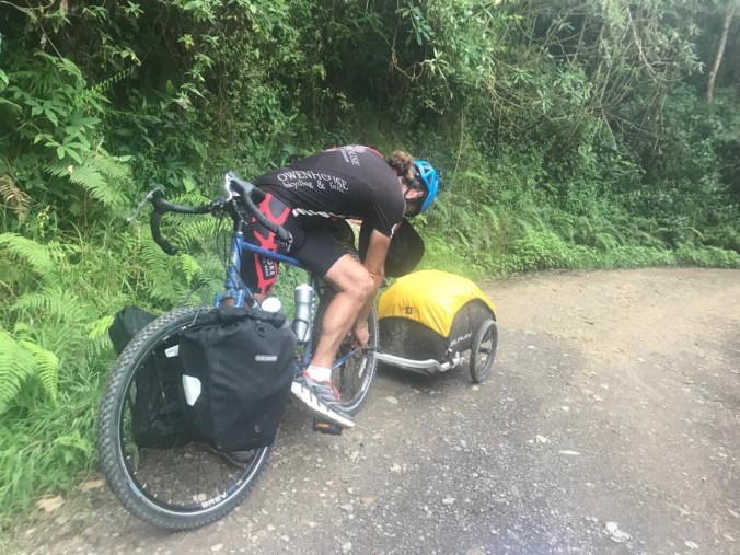
After leaving Suesca we have started making terribly awful but fun decisions. The first was taking a tiny mountain road the locals said might not be advisable. We were warned as we camped at a horse ranch where we ate dinner the evening before, that even though the FARC situation was over, the road our satnav chose was an un-policed road and until a year or two ago was risky. But, was probably OK now. The owner of the ranch also admitted it would avoid all traffic and we would probably see no cars.

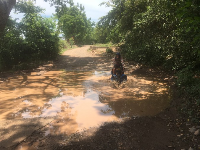
The road started with a climb to 9000 feet then plummeted down. Our presumption was we would be at 1200 feet before lunch with little to no pedaling.  The dense cloud forest at the top was, I will be honest, scary.  It was unpaved road with concrete at the steepest points on hairpin corners and some very large drops to the side. I quickly found going down such a steep road on a bike with a 50kg trailer is a terrifying ordeal where either my brakes were fully applied but the bike would accelerate into the whiteout with no idea if it was a cliff edge or road ahead, or my back wheel would lock up and trailer try to jack knife me. It had me ready to jump off the bike if needs be in a few places. The hideous squeal of straining brakes and fast repeating sound of spokes creaking and twinging under strain. I even put on my helmet in fear of a wipeout. After descending a few miles and settling into the descent as much as one could, there was a smell permeating its way through the air to us. It was not just a passing smell, it was strong and went on for miles. The forest stank of Cannabis. We didn’t see any people, but we couldn’t see much of anything. I remembered watching documentaries a few years ago about the remote mountain areas in Colombia and imagined just what was hidden up the hundreds of small mountain valleys departing the road side. The owner of the ranch may have been right about the road. But we descended down unhindered.

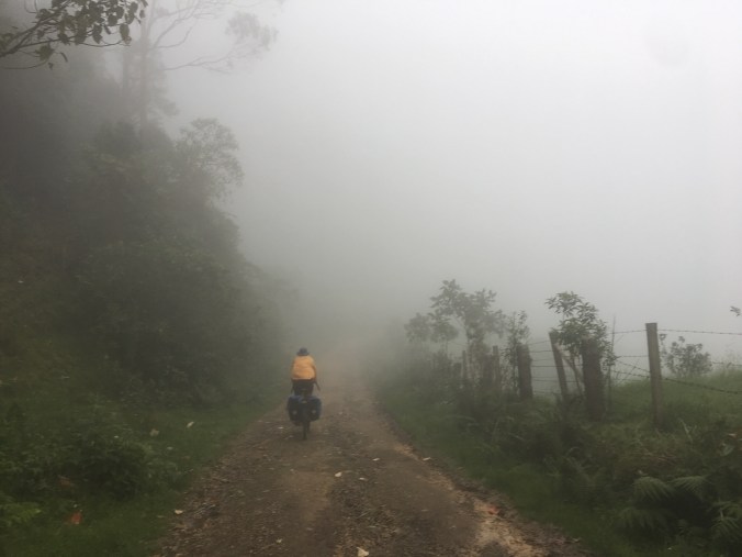
the picture doesn’t ever do justice .

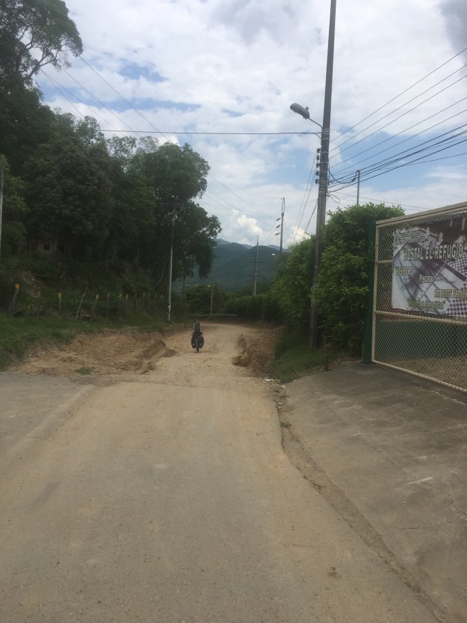
At about 5000 feet and with great relief we were spat out onto a paved road above a town, and quickly joined a main road we could have taken around the mountains. We followed the road and expected to have brunch at around 3500 feet. Unknown to us, at some point on this road, for this day, the traffic was changed from two-way to one way. It was bizarre, one second we had cars going our way, we rounded a corner, patched a tube on our trailer and suddenly to our confusion the traffic was flying uphill in both lanes. We couldn’t work it out, all the signs were in our direction and we were told at the next town down the traffic would be normal again, but there was no other way to the valley bottom. It started raining heavily. We decided we were in as much danger trying to cycle up in the rain as cycle down so carried on down the narrow shoulder. The shoulder soon gave way to road works and excavations, a crazy barrier hopping operation ensued. We were sprinting from one gap to the next between zooming cars. The next town was less than a mile but in heavy traffic it took hours. On reaching the town it was chaos with officers trying to direct the overwhelming number of cars. We found out this redirection would last until 7pm. Deciding it was enough danger for the day we booked a hotel and rested. The next day was easy and far less scary.

A couple of easy days riding and 150miles brought us to the edge of the Tatacoa Desert. Ahhh, deserts, the hot dry places that support a disproportionate amount of flies and cause untold amounts of saddle sores. Fortunately this one is small, more a dry valley bottom, but at 32c (90f+) and Cacti about, I guess it qualifies as Colombia’s second. We had the option of a beautiful straight paved highway or a dirt road off to the side. Being bad at decision making we took the desert road. What could have been an easy mornings ride to town turned into a hilly sandy gravel slog. I am thankful this desert was not as big as Colombias’ Northern desert and would be over quick. A lot of the road was covered in small river stones on hard base, which cause a lot of wheel spin problems cycling uphill. Imagine a hill of marbles and a trailer trying to pull you backwards. This results in frustration and after grinding to a halt then attemping to push the pile of steel and climbing gear up hills, with feet then in turn slipping back down. There were some cool tunnels near the start of the road in which light did not shine and I presume gave the overhead bats a nice home. Towards evening we reached the touristy part of the desert (there is a paved road in from the south) and decided to reside the night at a mud bath and spring. This was a nice break but in the morning while we packed, I was eaten alive by tiny flies. My legs speckled all over like some form of chicken pox that went into over kill.

Back to Climbing

We arrived in Suesca after a slow ride over a couple of passes from Villa de Leyva. An extra 6000ft of climbing, but relatively easy and broken up with an overnight stay beside a railway line with a curious cow for company. I had mixed feelings about Suesca this time. We have been here a week and climbed a few routes. Nerves have been getting the better of me. Though most the trad has been 5.6 (US Grade) and like walking up a staircase, the harder routes i didn’t lead (5.10+) felt real hard. I supposed due to training on a bicycle in the states instead of climbing for 6 months I am now like a heavy legged small armed tyrannosaurus , but slightly fatter.  One favourite route from last time we were here used to have a large undercut hold 15 foot off the ground. Now it lacks that hold and a large rucksack sized block of sandstone sits at the bottom of the crag, which in turn as it fell, has loosened a couple more holds, slightly nerving. This day also unleashed rain as we were finishing climbing, with lightning striking the top of the crag repeatedly with supersonic booms. We had been talking about taking a shower at some point and Suesca gave us a cold one in style.

After letting the rope dry a day or two we went out with the aim of climbing more technical routes and work on crack climbing ability, something I really don’t do well. A local guide having a day off joined us and introduced us to a slightly overhanging crack he lead and with a fun technical crux I fell off repeatedly. Its always nice to have someone push you on a route you wouldn’t have otherwise climbed and encourage technique.   My body feels pretty beat up now.

Along the way even in the first thousand mile we have been passing some brilliant national parks we would loved to have visited. But, the limitations on them put us off. With an increase in outdoor users creating more wear parks like Cocuuy have been closed almost permanently. This park used to have a one week hiking trail through beautiful paramo and alpine environments. Now it is limited to two half day hike for which you have to pay a park entry fee, have a guide and purchase insurance. This isn’t quite our style of park. The Sierra Nevada de Santa Marta rises from sea level to 17,000ft. But is virtually closed to tourists, there are a few trails for multi day hikes with a couple of local companies (including trips to the lost city Ciudad Perdida ), but the general consensus is it climbing peaks can’t be down without the help from the locals and the indigenous people who are suspicious of outsiders. They control the trails and the area has also been the point of ‘tourist taxes/kidnappings with gorilla groups. Though the problem is for the main part over, we decided to skip it with the aim of bigger mountains down the line with free access. Seeing how parks are ran in different countries does give me a real appreciation of the free park access back in the UK. I think the U.S. national park system giving back country users very cheap access is brilliant, and the free National forest system even more so. I guess in countries with a newly evolving outdoor scene are going to have a rougher start, but is good they are trying to control damage.

Over the past week my sleeping bag has been loosing feathers at quite a high rate. The little nicks and cuts I have neglected for so long showing white blossom each morning. The corners of the tent looking like a fox made it into the coop. My efforts to re-stuff the fluff back in are futile and yet- I haven’t dug through the bags for the repair tape we have hauled since we began. I think today might be the day I repair it, but then again, I could just climb instead?

Steamboat- going slow

I don’t think much can beat some tropical deep house music out on a porch overlooking a town while working on a bike. Today like yesterday has been a day of rest and recovery for me and the bike. I snapped a spoke about 300miles ago and have just got around to fixing it now. I had bought a spoke yesterday, went and sat in the park and stripped the back wheel to fit it, only to find the spoke was just too small to catch the thread. Round two today went without a hitch. and its satisfying to have straightened my first buckled wheel this trip, now spinning withing 1mm tolerance. I feel pretty good about this as its my first ever attempt at tightening spokes.

I’m stopped at a friends in Steamboat. Kathleen, a strong hiker I hiked a couple of sections of the CDT with in 2015 seemed more than happy enough to accommodate. She lives in a shared house with 5 other people. They are all healthy runners, cyclists and fitness trainers and fanatics. Eating healthy salads, and carrying pineapples to work for lunch. It puts my diet to shame but I make the excuse I’m burning more calories. I did eat a health dinner last night. Only to be wronged by an obtrusive box of chocolate cupcakes covered in choc mouse and white flakes this morning. (but they were really, really good!!). I washed it down with a couple of cups of strong coffee and carried on fixing and planning.

Colorado is a tricky place to cycle and climb, and stringing an efficient line through to 14,000 ft mountains without adding double passes each day seems no easy task.


My hair is now sufficiently down past my eyes enough to cause a hazard when cycling downhill or just around the town in traffic. Hopefully not long now till I can do the panten pro-v head shake to get it out of my eyes and look LIKE A BOSS!!

The skinny 40mm tyres I have been using have been just holding on the trail, allowing cruising at good speed on the smooth gravel and road sections. But negatively they have been wearing fast and skittering about on the downhill, the lack of traction is a minor concern. Its a surprisingly hard tyre size to get hold of from bike shops, bigger than the average hybrid wheel, but smaller than any other mountain bike tyre.

I think when i head off I will not look at the map but go by the route that looks visually most appealing. The wing it approach seems to serve well. With a 50/50 chance at any fork in the road. I’ve downloaded way points to the summits of the 14’ers roughly on route using Gaia gps showing me where i need to go. Ill cycle to Silverthorne have a easy day then begin (i don’t feel fully committed to this yet so the plan may change, I’m not sure where I can stash my bike while ticking peaks).


Cycling The Great Divide Basin


The divide basin is a large flat(ish) area that splits the rockies in wyoming. Its dusty, hot, there are lots of ticks that will try to bite you and its long. (136miles by the official bike route I think).

To get to the basin from Landers first i had to cycle the wrong way up 2300feet into a headwind. I resented this climb. I didn’t really need to cross the basin, I hiked across in 2015 and didn’t expect it to be much different. I could have taken the shorter road route but that wouldn’t be much of an adventure and i considered this a necessary evil on my trip.

I waited around Atlantic City, a small town on the edge of the basin with a few other hikers and bikers till after 4pm when it would start to cool, and set off, the water sources being about 22mile in, then 56mile, then Rawlins at the far side. I have two 1 litre water bottles but bought a couple of extra litres for just in case a flat tyre or something cataclysmic slowed me down, but i soon ditched the extra water with the thought there will be someone else out here if it goes south. I currently have a buckled back wheel and is is very slowly getting worse. hopefully it can make an extra 140miles to Steamboat springs where bike shops are plentiful.   I was very fortunate to have a tailwind for the first time and this was great motivation to keep going till after dark, knowing the next day it might be gone. I followed the tail of a storm, the clouds just keeping me in shade. The wildlife was brilliant, I had mule deer running all over, horses, cows, hares and after sundown, a coyote that kept me entertained for a while. The coyote seemed chilled, but always tried to keep behind me, if I turned to it it would back a distance away and circle again. I rode into the dark with a poor headtorch that I love, and nearly wrapped a few times hitting ruts and sand. But progress is progress.

Sunset and sunrise are worth watching, the colours are unreal, like a brilliant filter has been applied. I took an hour out in the morning to play with my camera and see what i can achieve. The night sky was so clear, lighting every inch of ground. The below video is in the divide and I think its mule deer running across my path. This was great fun to see repeatedly over 60miles.

This is the sunrise while i was packing up and getting ready to cycle. All in i wouldn’t recommend cycling the divide or walking it, but it is beautiful and a dirt road runs through it. Worth a trip for the safari.

I am trying to work out how to climb as many 14,000ft+ peaks as possible as I cycle through Colorado, maybe one a day southbound? I’m gonna finish this beer and hit the road.

Love ya’ll. Benjamin


A change of Direction going the right way

So, I was heading back to the trail Via Amtrak when i bumped into an old friend Lucky Larry; and was inspired. Instead of hiking the whole divide, Why not cycle the great divide and climb the interesting parts? With the increased daily mileage so fewer days= less food, a bicycle would pay for itself by Mexico (Is what i have told myself)

This idea was in the back of my mind as i hitched from East Glacier to Browning towards where i left off. At Browning after a couple hours waiting, with not many cars passing, a young guy pulled over called Skyler. He agreed to driver me and after a small diversion I decided to stop the night in Lincoln. On route Sky said he wanted to hike up a pass we were going over. We pulled in at the top of the pass, he goes to the boot and pulls out some trainers.

‘I found these at the hostel, can you believe someone would chuck them away’.

I was surprises to be staring at the trainers i chucked away in East Glacier which caused my feet so much grief through the snow and subsequently a week off trail.  This was a entertaining twist. After the climb it was pretty much settled I might as well go back to Missoula to buy a bicycle. Sky gave me a lift in and breakfast in his awesome self built trailer house. At 9am I started searching the town for a bike, and towards the end of the day was getting desperate to find the spec i wanted at an affordable price, everywhere I went had just sold out, or had the wrong frame size. Sarah and Josh put me up again for the night and the next morning I met a guy from a bike shop to buy a used bike that was perfect. My steel framed machine of speed, mechanical discs, 40mm tyres(with space for a little more), wide drop bars. I set off around lunchtime and cycled around 50mile to Ovander, stopped briefly by a flat tyre from a piece of hard wire. In Ovander they welcome cyclists with open arms and contribution based accommodation($5), I opted to spent the night in a trailer with a comfortable mattress and grab a burger in the bar.

Saturday morning i cycled into Lincoln to join the great divide mountain bike trail, as I arrived in the town the street were lined with people, I presumed they were all there to greet me and send me on my way, but to my disappointment found they were actually getting ready for the 4th July parade in a few minuted time. So i took my place among the ranks and waited. The parade started and within a minute was handed free beer and beef jerky. Sweets were chucked to the children and the streets lined with red white and blue, cowboy hats and solid boots. I talked with the locals for a while then tried to set off. Across the road a family stopped me and ensured i had at least a cup of fresh lemonade. The children were using the money made to buy candy.

I set off at 1pm hoping to go a few miles, but the route drew me in and I was soon slaughtering myself, mile by mile up and up. The first descent was described as steep, and yes it was, half way down i pinched my second tube. The trail is easy but this was worrying in the first 15 mile off road as I had one more tube in reserve having spent 2 already. There was a camp area in the next valley, but I was flying on adrenaline. So climbed the second pass , this descend was smooth but with large washed out sections running and weaving down the trail, making me nervous on my 40mm gravel tyres. Lower where it was slightly rockier i started chucking the bike about; But the steel machine kept going, the wheels staying unbuckled to my relief. By half 7 I thought there is no point in stopping this close to the pass, so pushed and camped then night just off the road down to Helena. I planned on spending a day gettin to Lincoln and two days getting to Helena but had made it all on one day. Yusss!!!!!. The night was spent with what i presume was a pack of coyotes howling a couple hundred yards away. I was downwind and glad to be receiving no attention, with only an inner tent between me and them.

Sunday morning I have rolled downhill into town and am now sat back drinking a beer waiting for my luxury 2* motel room to be made ready. Ahhh hot shower, clothes washing and A/C (I hope).

In summary, the plan has changed, by covering the boring sections of trail 2-3 times faster, the bike will pay for itself and i will cover ground quicker. I shall climb peaks on the way down to Mexico as I choose, hopefully a good few 14ers (no fixed plan but maybe one per day) and a bit of time in the wind river range prior.

I need a name for my bike, any suggestions???? The name i like will be painted or at least marker penned onto the frame forever more.